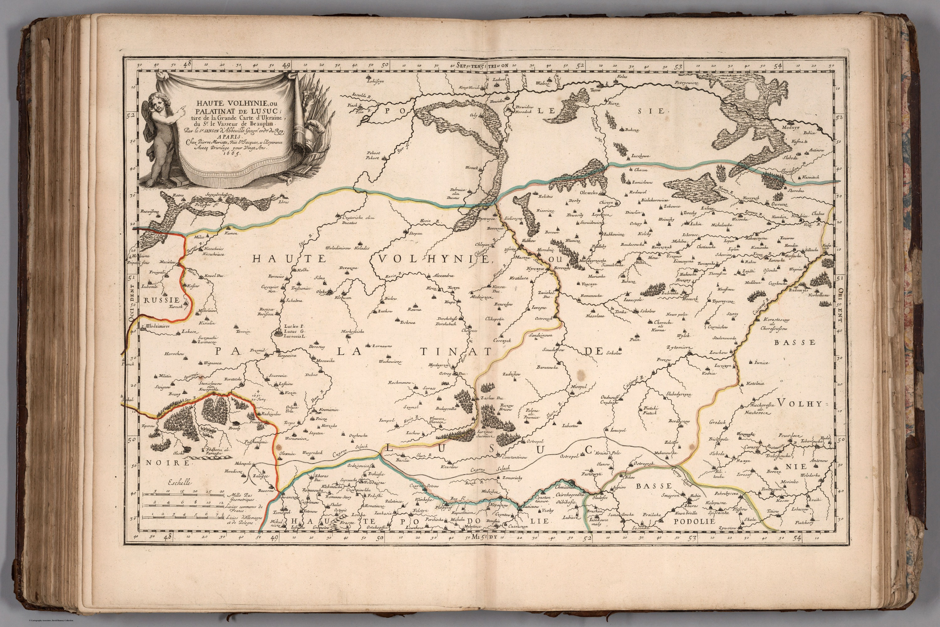
Nicolas Sanson, Guillaume Sanson. Haute Volhynie (Upper Volyn). 1665
Розділ: Мапи Волині
Author: Sanson, Nicolas, (1600-1667)
Author: Sanson, Guillaume (1633-1703)
Date: 1665
Short Title: Volyn, Ukraine.
Publisher: Cloistre de S Nicolas du Louvre
Publisher Location: Paris
Type: Atlas Map
Obj Height cm: 39 Obj Width cm: 58
Scale 1:870,000
Country: Ukraine
Full Title: Haute Volhynie (Upper Volyn/Верхня Волинь)
Pub Title: Cartes et Tables de la Geographie Ancienne et Nouvelle ou Methode pour s'Instruire Avec facilite de la Geographie, et Connoistre des Empires, Monarchies, Royaumes, Estats, Republiques, et Peuples ... Par les Srs. Sanson, Geographes du Roy ... A Paris. Chez l'Autheur ... 1697. (Maps and Tables of Geography Ancient and Modern or Methods for Easy Instruction of the Geography and Understanding of Empires, Monarchies, Kingdoms, States, Republics, and Peoples ... By Srs. Sanson, Geographers to the King ... In Paris ... House of the Author ... 1697.)
Pub Note: This is a very rare edition of Sanson's maps, published by his son, Guillaume Sanson. The title page is dated 1697 but the latest date on a map in the atlas is 1709. In French and Latin. Three volume set. Volume I is a huge set of hierarchies presenting the relative arrangement of thousands of places. Each page has from four to six levels of places, for example ranging from a country level down through states and counties on down to cities and towns. In cataloging, for the title of each page,we just list the first highest level place on the page. In the Short Title, liberty as been taken to explain the subjects of the page in English in more detail. Relief shown by sketches. Outline color.
(пер.: Це дуже рідкісне видання карт Сансона, опубліковане його сином Гійомом Сансоном. Титульна сторінка датована 1697 роком, але найпізнішою датою на карті в атласі є 1709 рік. Французькою та латинською мовами. Набір з трьох томів. Том I — це величезний набір ієрархій, що представляють відносне розташування тисяч місць. Кожна сторінка містить від чотирьох до шести рівнів місць, наприклад, від рівня країни до штатів і округів і до міст і селищ. У каталогізації для заголовка кожної сторінки ми просто вказуємо перше місце найвищого рівня на сторінці. У Короткій назві було дозволено більш детально пояснити тему сторінки англійською мовою. Рельєф зображений ескізами. Колір контуру).
Джерело: